From Wikipedia, the free encyclopedia
| Amfipoli Αμφίπολη |
|
|---|---|
| Location | |
| Coordinates | 40°49′N 23°50′ECoordinates: 40°49′N 23°50′E |
| Government | |
| Country: | Greece |
| Administrative region: | Central Macedonia |
| Regional unit: | Serres |
| Population statistics (as of 2011)[1] | |
| Municipality | |
| - Population: | 9,182 |
| - Area: | 414.3 km2 (160 sq mi) |
| - Density: | 22 /km2 (57 /sq mi) |
| Municipal unit | |
| - Population: | 2,615 |
| Community | |
| - Population: | 185 |
| Other | |
| Time zone: | EET/EEST (UTC+2/3) |
| Auto: | ΕΡ |
Amphipolis (Modern Greek: Αμφίπολη; Ancient Greek: Ἀμφίπολις) is a municipality in the Serres regional unit of Greece. The seat of the municipality is Rodolivos.[2] In ancient times, it was a city in the region once called Edonia in the present-day region of Central Macedonia. It was built on a distance of around 5 kilometres (3 mi) from the Aegean Sea coast.
Contents
History
Origins
Archaeology
has uncovered remains at the site dating to approximately 3000 BC. Due
to the strategic location of the site it was fortified from very early.
In the 8th and 7th century BC the site of Amphipolis was ruled by Illyrian tribes.[3] Xerxes I of Persia
passed during his invasion of Greece of 480 BC and buried alive nine
young men and nine maidens as a sacrifice to the river god.[citation needed] Near the later site of Amphipolis Alexander I of Macedon defeated the remains of Xerxes' army in 479 BC.
Throughout the 5th century BC, Athens
sought to consolidate its control over Thrace, which was strategically
important because of its primary materials (the gold and silver of the Pangaion hills and the dense forests essential for naval construction), and the sea routes vital for Athens' supply of grain from Scythia. After a first unsuccessful attempt at colonisation in 497 BC by the Milesian Tyrant Histiaeus,
the Athenians founded a first colony at Ennea-Hodoi (‘Nine Ways’) in
465, but these first ten thousand colonists were massacred by the Thracians.[4] A second attempt took place in 437 BC on the same site under the guidance of Hagnon, son of Nicias.
The new settlement took the name of Amphipolis (literally, "around
the city"), a name which is the subject of much debates about lexicography. Thucydides claims the name comes from the fact that the Strymon flows "around the city" on two sides;[5] however a note in the Suda (also given in the lexicon of Photius) offers a different explanation apparently given by Marsyas, son of Periander: that a large proportion of the population lived "around the city". However, a more probable explanation is the one given by Julius Pollux: that the name indicates the vicinity of an isthmus. Furthermore, the Etymologicum Genuinum
gives the following definition: a city of the Athenians or of Thrace,
which was once called Nine Routes, (so named) because it is encircled
and surrounded by the Strymon river. This description corresponds to the
actual site of the city (see adjacent map), and to the description of
Thucydides.
Amphipolis subsequently became the main power base of the Athenians in Thrace and, consequently, a target of choice for their Spartan adversaries. The Athenian population remained very much in the minority within the city.[6] A rescue expedition led by the Athenian strategos (general, and later historian) Thucydides had to settle for securing Eion
and could not retake Amphipolis, a failure for which Thucydides was
sentenced to exile. A new Athenian force under the command of Cleon failed once more in 422 BC during a battle at which both Cleon and Brasidas
lost their lives. Brasidas survived long enough to hear of the defeat
of the Athenians and was buried at Amphipolis with impressive pomp. From
then on he was regarded as the founder of the city[7][8][9] and honoured with yearly games and sacrifices. The city itself kept its independence until the reign of the king Philip II despite several other Athenian attacks, notably because of the government of Callistratus of Aphidnae.
Conquest by the Romans

Fortifications and bridge of Amphipolis.
In 357 BC, Philip removed the block which Amphipolis presented on the
road to Macedonian control over Thrace by conquering the town, which
Athens had tried in vain to recover during the previous years. According
the historian Theopompus, this conquest came to be the object of a secret accord between Athens and Philip II, who would return the city in exchange for the fortified town of Pydna, but the Macedonian king betrayed the accord, refusing to cede Amphipolis and laying siege to Pydna.
After the conquest by Philip II, the city was not immediately
incorporated into the kingdom, and for some time preserved its
institutions and a certain degree of autonomy. The border of Macedonia
was not moved further east; however, Philip sent a number of Macedonian
governors to Amphipolis, and in many respects the city was effectively
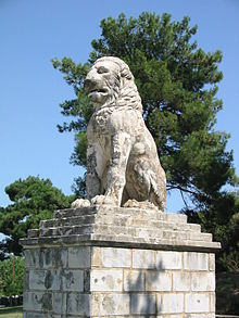
‘Macedonianized’. Nomenclature, the calendar and the currency (the gold stater, installed by Philip to capitalise on the gold reserves of the Pangaion hills, replaced the Amphipolitan drachma) were all replaced by Macedonian equivalents. In the reign of Alexander, Amphipolis was an important naval base, and the birthplace of three of the most famous Macedonian admirals: Nearchus, Androsthenes[10] and Laomedon whose burial place is most likely marked by the famous lion of Amphipolis.
Amphipolis became one of the main stops on the Macedonian royal road (as testified by a border stone found between Philippi and Amphipolis giving the distance to the latter), and later on the ‘Via Egnatia’, the principal Roman road
which crossed the southern Balkans. Apart from the ramparts of the
lower town (see photograph), the gymnasium and a set of well-preserved
frescoes from a wealthy villa are the only artifacts from this period
that remain visible. Though little is known of the layout of the town,
modern knowledge of its institutions is in considerably better shape
thanks to a rich epigraphic documentation, including a military
ordinance of Philip V and an ephebarchic (?) law from the gymnasium. After the final victory of Rome over Macedonia in a battle in 168 BC, Amphipolis became the capital one of the four mini-republics, or merides, which were created by the Romans out of the kingdom of the Antigonids which succeeded Alexander’s empire in Macedon. These merides were gradually incorporated into the Roman client state, and later province, of Thracia.
Revival in Late Antiquity
During the period of Late Antiquity, Amphipolis benefited from the increasing economic prosperity of Macedonia, as is evidenced by the large number of Christian churches
that were built. Significantly however, these churches were built
within a restricted area of the town, sheltered by the walls of the acropolis.
This has been taken as evidence that the large fortified perimeter of
the ancient town was no longer defendable, and that the population of
the city had considerably diminished.
Nevertheless, the number, size and quality of the churches
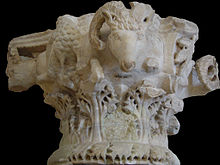
constructed between the fifth and sixth centuries are impressive. Four basilicas adorned with rich mosaic floors and elaborate architectural sculptures (such as the ram-headed column capitals - see picture) have been excavated, as well as a church with a hexagonal central plan which evokes that of the basilica of St. Vitalis in Ravenna.
It is difficult to find reasons for such municipal extravagance in such
a small town. One possible explanation provided by the historian André Boulanger is that an increasing ‘willingness’ on the part of the wealthy upper classes in the late Roman period to spend money on local gentrification projects (which he terms euergetism,
from the Greek verb εύεργετέω, (meaning 'I do good') was exploited by
the local church to its advantage, which led to a mass gentrification of
the urban centre and of the agricultural riches of the city’s
territory. Amphipolis was also a diocese under the metropolitan see of Thessalonica - the Bishop of Amphipolis is first mentioned in 533. The bishopric is today listed by the Catholic Church as a titular see.[11]
From the reduction of the urban area to the disappearance of the city
The Slavic invasions
of the late 6th century gradually encroached on the back-country
Amphipolitan lifestyle and led to the decline of the town, during which
period its inhabitants retreated to the area around the acropolis. The
ramparts were maintained to a certain extent, thanks to materials
plundered from the monuments of the lower city, and the large unused
cisterns of the upper city were occupied by small houses and the
workshops of artisans. Around the middle of the 7th century AD, a
further reduction of the inhabited area of the city was followed by an
increase in the fortification of the town, with the construction of a
new rampart with pentagonal towers cutting through the middle of the
remaining monuments. The acropolis, the Roman baths, and especially the Episcopal basilica were crossed by this wall.
The city was probably abandoned in the eighth century, as the last
bishop was attested in 787. Its inhabitants probably moved to the
neighbouring site of ancient Eion, port of Amphipolis, which had been
rebuilt and refortified in the Byzantine period under the name “Chrysopolis”. This small port continued to enjoy some prosperity, before being abandoned during the Ottoman period.
The last recorded sign of activity in the region of Amphipolis was the
construction of a fortified tower to the north in 1367 by Grand Primicier Jean and the Stratopedarch Alexis to protect the land that they had given to the monastery of Pantokrator on Mount Athos.
Archaeology

Fresco from a house (Hellenistic period).
The site was rediscovered and described by many travellers and
archaeologists during the 19th century, including E. Cousinéry (1831)
(engraver), L. Heuzey (1861), and P. Perdrizet (1894–1899). In 1934, M.
Feyel, of the École française d'Athènes, led an epigraphical mission to the site and uncovered the remains of a funeral lion (a reconstruction was given in the Bulletin de Correspondance Hellénique, a publication of the EfA which is available on line).[12] However, excavations did not truly begin until after the Second World War. The Greek Archaeological Society
under D. Lazaridis excavated in 1972 and 1985, uncovering a necropolis,
the rampart of the old town (see photograph), the basilicas, and the
acropolis.
The Tomb of Amphipolis
In 2014 Greek archaeologists unearthed northeast of Amphipolis (location: 40.8394°N 23.8628°E) a vast tomb from the last quarter of the 4th century BC, known as the Hellenistic Period,
the biggest burial tomb ever unearthed in Greece. It is believed that
it belonged to an important figure from the late period of the reign of Alexander the Great
although the identity of the deceased remains unknown as of September
8, 2014, since no remains have yet been revealed and therefore examined.[13]


